| |
Current 3-D GPR Projects
Diffraction imaging of sub-vertical fractures and karst with full-resolution 3D Ground-Penetrating Radar |
|
| Investigators: Mark Grasmueck, Miquel Coll Quinta, Kenri Pomar, Gregor P. Eberli |
|
Vertical fractures with openings of less than one centimeter and irregular karst cause abundant diffractions in Ground-Penetrating Radar (GPR) records. GPR data acquired with half-wavelength trace spacing are uninterpretable as they are dominated by spatially undersampled scattered energy. To evaluate the potential of high-density 3D GPR diffraction imaging a 200 MHz survey with less than a quarter wavelength grid spacing (0.05 m x 0.1 m) was acquired at a fractured and karstified limestone quarry near the village of Cassis in Southern France. After 3D migration processing, diffraction apices line up in sub-vertical fracture planes and cluster in locations of karstic dissolution features. The majority of karst is developed at intersections of two or more fractures and is limited in depth by a stratigraphic boundary. Such high-resolution 3D GPR imaging offers an unprecedented internal view of a complex fractured carbonate reservoir model analogue. As seismic and GPR wave kinematics are similar, improvements in the imaging of steep fractures and irregular voids at the resolution limit can also be expected from high-density seismic diffraction imaging.
Description of Movies:
Unmigrated horizontal slice movie from the 200 MHz full-resolution Cassis 3D GPR survey. The movie scans a depth range from 1.7 to 2.2 m below the quarry floor. Circle signatures are point diffractions caused by sub-wavelength features related to fractures and karst.
In the 3D migrated movie the point diffractions are focused into small dots delineating sub-vertical fracture trends and clustering in karst anomalies. Rapid animation of the horizontal slices visualizes fracture planes due to optical continuity of diffractor points caused by small scale heterogeneity within the fractures.
Amplitude data are displayed with a continuous grey scale colourbar. White is positive and black is negative
|
| |
|
|
Non-Destructive 3D Imaging of Gopher Tortoise Burrows |
|
| Investigators: F.Despinois, A.Kinlaw, M.Grasmueck, and D.Viggiano |
Florida's Gopher Tortoise is known to dig long and deep tunnels in sand for shelter and protection during extreme temperatures, drought and fire. At least 362 other species of animals use these burrows at some stage in their life or seasonal cycle. Unfortunately Gopher Tortoise populations are declining due to urban development. One of the key aspects for understanding and protection is the knowledge of geometry and extent of the burrows. Current Tortoise burrow exploration relies primarily on invasive methods, which either destroy the burrow or lack geometric precision. Examples are injecting foam inside the burrow before excavation, probing with rods, insertion of cameras or 2D Ground Penetrating Radar (GPR) profiling.
In collaboration with A. Kinlaw from the University of Florida, we tested the new high resolution 3D GPR system developed at RSMAS to non-invasively image four burrow sites in the Sandhills of the Ocala National Forest. At each site we acquired a 3D GPR scan within 40 minutes covering an area of 10x10 m with a resolution 5x10 cm 3D processing and visualization of the subsurface data reveal to our knowledge for the first time the true shape of Gopher Tortoise burrows. Interestingly each burrow has a different geometry: 2 turn left, one turns right and one is straight. The longest burrow is 12.5 m and reaches a depth of 4.6 m.
In summary, the 3D GPR successfully imaged the complex geometry of burrows without damage. This opens the possibility for monitoring burrow development over time helping to gain understanding and protection of Gopher Tortoises.
|
| |
|
|
Miami Oolitic Limestone 3D GPR: Sedimentology, archeology, depositional environment |
|
| Investigators: Grasmueck, Weger |
This 100 MHz 3D GPR survey in an oolitic limestone environment offers new insight into the spatial distribution of sedimentary features. It was possible to image the internal architecture of a complex oolitic sandbar system on a submeter scale and to confirm relationships that exist between decimeter-scale sandwaves and the prograding barrier bar. Only the dense (0.1 x 0.2 m) grid spacing used for this survey provided the necessary basis for accurate description of 3D internal anatomy and paleoenvironmental parameters such as dominant wave and current direction. Such reconstruction of depositional environment would not have been possible with commonly used 0.5-1 m line separation.
3D GPR data volumes, together with the 3D technologies from seismic exploration, will enable unprecedented quantification of internal anatomy of sedimentary bodies, filling the scale gap between borehole and seismic information. Advances in 3D GPR data acquisition technology are needed to make such surveys commercially viable and not only a matter of academic research.
Description of Movie:
Horizontal-slice animation from 0 to 6 m depth through 3D-migration-processed Miami oolite 3D GPR data volume. Graphic pixels correspond to real measurements on a 0.1 x 0.2 m grid with no interpolation applied. Vertical separation of consecutive slices is 1.2 cm. By scrolling through data volume, characteristic internal patterns of anthropological and sedimentological origin can be seen: 0-1 m depth, soil with remnants of human activities; 1-2.7 m depth, dipping beds from prograding oolitic barrier bar; 2.7-6 m depth, subhorizontal ooid shoal packages with internal lineation patterns.
|
| |
|
|
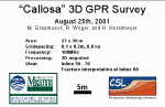
Callosa 3D GPR: Fracture imaging in Limestone |
|
| Investigators: M. Grasmueck, R. Weger, H. Horstmeyer |
Noninvasive 3D ground-penetrating radar (GPR) imaging with submeter resolution in all directions delineates the internal architecture and processes of the shallow subsurface. Full-resolution imaging requires unaliased recording of reflections and diffractions coupled with 3D migration processing. The GPR practitioner can easily determine necessary acquisition trace spacing on a f-k plot of a representative 2D GPR test profile. Quarter wavelength spatial sampling is a minimum requirement for full-resolution GPR recording. An intensely fractured limestone quarry serves as a test site for a 100 MHz 3D GPR survey with 0.1 m x 0.2 m trace spacing. This example clearly defines the geometry of fractures in four different orientations including vertical dips to a depth of 20 m. Decimation to commonly used half wavelength spatial sampling or only 2D migration processing make most fractures invisible. The extra data acquisition effort results in image volumes with submeter resolution both in the vertical and horizontal directions. Such 3D datasets accurately image fractured rock, sedimentary structures and archeological remains in previously unseen detail. This makes full-resolution 3D GPR imaging a valuable tool for integrated studies of the shallow subsurface.
Movie Descriptions:
Unmigrated 3D Timeslices:
Horizontal-slice animation from unmigrated Callosa fractured limestone 3D GPR data set. Circles on slices are caused by diffractions from fractures.
3D Migrated Timeslices
Horizontal-slice animation from migrated Callosa fractured limestone 3D GPR data set.With rapid animation of consecutive time slices, spatial continuity and dip of fractures can be visually assessed. Focused diffractions line up as elements of four discrete sets of fracture orientations.
3D Migrated Inlines
Vertical profile animation from migrated Callosa fractured limestone 3D GPR data set. With rapid animation of consecutive profiles, spatial continuity and dip of fractures can be visually assessed. Subhorizontal fractures are traceable as semicontinuous reflections with consistent dip. Near-vertical fractures are imaged by numerous focused diffraction points aligned in steep orientations.
|
| |
|
|
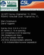
What is under the RSMAS Beach Volley Ball Court |
|
| Investigators: M. Grasmueck, D. Viggiano |
Considering recent advances in seismic and medical 3D imaging, shallow subsurface imaging is seriously lagging behind, primarily due to lack of efficient measurement techniques supported by lightweight 3D GPR surveying equipment. Presently, it may take days to weeks to produce interpretable high resolution 3D cubes. We are currently developing a next generation acquisition system that surpasses existing equipment in productivity and precision. For a demonstration to 30 professional geologists, we recorded a 140 squaremeter 3D survey with a grid resolution of 5cm x 10cm in 50 minutes. An hour after the last trace was recorded we presented 3D animations of the internal structure of the ancient beach.
Description of Movie:
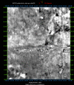
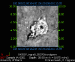
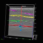
Before acquiring the 3D GPR survey we dug some shallow trenches in the shape of the Letters C S L and ran along it with a running water hose before closing the trenches again. Due to its sensitivity to changes in water content, the GPR images the infiltrating water. One week later slight traces of the letters were still visible on a repeat survey. Below a depth of 80 cm we can see SE dipping beds which are the sand layers of the ancient beach dipping towards the Ocean. Today the RSMAS beach is located 50m further to the SE. Circular diffractions are abundant in the middle of the survey area just underneath the volleyball net. Some players might have lost some valuable objects when smashing hard. Excavation still has to reveal the truth.
|
| |
|
|
3D GPR imaging of a fractured and hydrothermally altered limestone quarry |
|
| Investigators: M. Grasmueck, D. Viggiano, T. Smith |
For the first out-of-Florida test in upstate New York we packed the equipment in 8 airline checkable luggage pieces and successfully recorded during 4 days several 2D and 3D surveys. Even with low penetration depth, full-resolution 3D GPR can still provide a 'floor plan' of the fracture network in an outcrop covered with rubble. Based on the GPR survey results, the most interesting excavation sites can be chosen.
Description of Movie:
Horizontal slices through 3D GPR survey covering an area of 26.3 m x 30 m with a survey grid of 0.05 m x 0.10 m using 250 MHz GPR antennae. Depth range 0.67 m to 0.93 m. Interpretation on 0.8 m depth slice: Yellow = outline of buried fault segment, Red= fractures, Green = topography related to buckling up of elsewhere horizontal strata on the East side of the fault and slight depression to the West.
|
| |
|
|
Using 4D GPR to Track Fluid Flow in the Vadose Zone |
|
| Investigators: M. Grasmueck, D. Viggiano |
Repeated GPR surveys are sensitive to a change of water saturation as a response.
Time-lapse 3D (i.e., 4D) GPR imaging of the vadose zone could be used to monitor ground water infiltration, contaminant migration, irrigation efficiency, plant root water uptake and fertilizer distribution.
In large parts of urban Miami the vadose zone is characterized by oolitic carbonates, where laterally varying small-scale stratigraphy and crosscutting dissolution features control transport pathways. Water from heavy summer storms that ponds on the surface to depths of 5-7cm disappears within a fraction of an hour. Subsequent to the rapid infiltration, little is known regarding the flow pathways in this complex environment.
In order to reach our long-term goal of extracting hydrologically relevant and quantitative parameter volumes we have initiated an integrated study involving full-resolution 3D and 4D Ground Penetrating Radar (GPR) imaging, drilling, excavation, outcrop inspection, lab measurements on samples and synthetic GPR modeling. Preliminary results show that the bulk rock-permeability is controlled by infilled, high-permeability dissolution features, which act as preferential pathways to short-circuit the vadose zone.
Movie Descriptions
Surface Infiltration:
Horizontal slice animation taken from three repeated 3D GPR surveys before, during, and 28 hours after water injection into a sand-filled dissolution cone. Data were acquired with 250 MHz antennae on a 5x10cm grid. The unmigrated 3D data volumes reveal the anisotropic propagation of the wetting front. The signal patterns in peripheral areas of the 3D survey remain the same throughout the repeats. This indicates no change in water content beyond the reach of the central sink, but also the excellent reproducibility of the repeated GPR measurements.
Borehole Infiltration:
For imaging fluid flow in undisturbed oolitic limestones several meters away from a borehole we conducted an open-hole, vadose zone infiltration experiment monitored by hourly repeated 3D GPR surveys. Data acquisition with 250 MHz antennae on a dense 5 x 10 cm bingrid, centimeter precise repositioning of GPR antennae and 3D migration reveals the propagation of the moisture front. The movie shows the same horizontal slice at 3m depth extracted from seven 3D surveys acquired every hour during injection of 500 liters of water per hour. The red cross is the location of the borehole.
|
| |
|
|
Hydro - Geophysics Training/Research Opportunity |
|
| Investigators: You? |
The objective of this project is to characterize and quantify vadose zone flow and transport and develop 4D GPR imaging workflows integrating geophysics and hydrology. State-of-the-art GPR acquisition and 3D visualization available. Collaboration with researchers from Environmental Geophysics Research Group (University of South Florida), the Env. Physics Group (University of Connecticut), the Office of Ground Water (Branch of Geophysics at the USGS) and the Env. Science and Engineering Section (EPFL, Switzerland).
For more Info: mgrasmueck@rsmas.miami.edu
|
| |
|
|
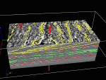
Full-Resolution 3D Radar Stratigraphy of complex Oolitic Sedimentary Architecture |
|
| Investigators: A.Neal, M.Grasmueck, D.F. McNeill, D.A.Viggiano, G.P.Eberli |
At the field scale it is often difficult to define the three-dimensional form of depositional units or facies within sediments or sedimentary rocks, due to inherent spatial bias in traditional data sources such as outcrops, cores and trenches. This study demonstrates that a new ground-penetrating radar (GPR) data collection and interpretation technique, full-resolution 3D radar stratigraphy, has the potential to overcome this problem in many instances.
Southwest of Miami, the paleotopography of Upper Pleistocene Miami Limestone Formation indicates the former presence of a large oolitic barrier bar, backed by extensive ooid shoals. On the barrier bar a full-resolution 3D GPR data set was collected with 250 MHz antennae, over an area of 45 x 24 m. Depth of radar wave penetration was around 6 m. After suitable processing, both horizontal and vertical resolution was approximately 0.1 m for the 6500 cubicmeter rock volume. State-of-the-art visualization and interpretation techniques allow definition of a complex 3D radar stratigraphy for the data, without spatial aliasing. Subsequent sedimentological interpretation was aided by three closely-spaced boreholes within the survey area and extensive outcrops in a nearby canal.
A hierarchy of radar surfaces defines two main radar package types: A (green) and B (yellow). Radar surfaces correlate directly with bounding surfaces and demarcate a hierarchy of depositional units or architectural elements. Radar facies consist of sets of reflections generated by cross-bedding within a particular depositional unit. Type A radar packages are interpreted as oolitic shoal deposits consisting of tidal bars covered by predominantly-ebb-orientated, straight-crested, sand waves. Subsequent barrier-bar formation resulted in the overlying Type B radar packages. Geometry of these radar packages indicates barrier-bar growth was broadly parallel to the regional longshore transport direction.
|
| |
|
|
||©Comparative Sedimentology Laboratory 2022|| |
|